0.74 Acre on Cavalcade
5113 Cavalcade · Houston, TX 77026 · 29.8009° N, 95.3190° W
35 days on marketUpdated 5 weeks ago
Records & area insights ↓Image 1 of 2: Photo
- Asking
- $525,000
- Acres
- 0.74
- Square feet
- 32,234
- Price / acre
- $709,459
- Frontage
- ~251 ft
- Status
- For Sale
Overview
5113 Cavalcade Street presents a two-parcel assemblage totaling approximately 32,234 square feet (0.74 acres) in Houston's Kashmere Gardens area. The offering combines a land parcel with an adjacent improved retail/commercial parcel, creating a flexible infill opportunity for an owner-user, investor, or redevelopment buyer seeking frontage and site control along Cavalcade. Existing improvements on the improved parcel provide potential interim utility while a buyer evaluates long-term repositioning or redevelopment plans. With the parcels assembled and sold together, the site offers scale for neighborhood retail, service commercial, contractor-oriented uses, or a covered land strategy, subject to zoning and city approvals. 5113 Cavalcade Street presents a compelling two-parcel commercial assemblage totaling approximately 32,234 square feet (0.74 acres) in Houston. The offering combines a ±14,810 SF land parcel with an adjacent ±17,424 SF improved commercial parcel, creating a larger, more functional site than either parcel would offer independently. From a valuation standpoint, the assemblage should be viewed primarily as a land-driven opportunity with contributory value from existing improvements. The improved parcel includes an older commercial structure, but the available source material reflects inconsistent building-area data. Because of that, the most supportable valuation approach is to emphasize the combined site size, frontage, utility, and redevelopment flexibility, while assigning only limited weight to the current improvement until further verification is completed. In other words, the existing structure may provide interim utility or covered-land value, but the core investment thesis remains tied to the underlying real estate and assemblage potential.
Potential uses
Source attribution
Listing information provided by KW Premier.
Listed by
1 active · 0 sold on Parcel Neighbor
Profile and listingsExplore the possibilities
What could this land become?
Reviewed by our team
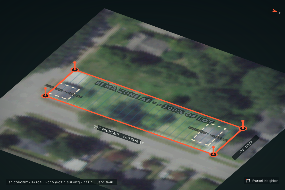
Today
The land as it is
Approximately 251 ft of frontage by 70 ft of depth. Select a scenario to see one way this parcel could potentially be used — drawn to the lot's approximate dimensions.
Visualization is for illustrative purposes only and does not represent approved construction, zoning approval, engineering feasibility, permitting or guaranteed development capacity.
Compare scenarios
The same lot, use by use
| Scenario | Capacity (conceptual) | Lot improved | Cost to get ready | Use-fit | |
|---|---|---|---|---|---|
| Duplex | ~8 duplex units (conceptual) | 23% | $21K–$69K$2,613–$8,582 site prep per unit | 7 favorable2 to confirm2 unknown | View KML · GeoJSON |
| Townhomes | ~8 townhome units (conceptual) | 23% | $21K–$69K$2,613–$8,582 site prep per unit | 7 favorable2 to confirm2 unknown | View KML · GeoJSON |
| Single-Family | ~4 homesites (conceptual) | 21% | $21K–$69K$5,226–$17K site prep per unit | 7 favorable2 to confirm2 unknown | View KML · GeoJSON |
| Self Storage | Doesn't fit on this lot | 43%paved · office | $449K–$926K | 5 favorable5 to confirm3 unknown | View KML · GeoJSON |
| Retail | ~500 sq ft retail (conceptual) | 2% | $21K–$69K | 5 favorable4 to confirm3 unknown | View KML · GeoJSON |
Counts come from the concept drawn on the county parcel outline with a conceptual detention area, floodplain and any pipeline easement kept open; cost ranges multiply the drawn quantities by regional unit costs. Unit costs are published 2026 regional figures (TxDOT and county bid prices, industry cost guides), not quotes from our contractors. Conceptual only — subject to engineering, permitting and a title review. The KML and GeoJSON files carry each concept on the lot lines for your architect or engineer.
Design it yourself
Site Studio: test what this lot could become
Pick a use, move the gate, change what parks here, run the rows the other way, place your own buildings or fence off areas — and watch capacity, lot coverage and a rough cost range update live, in plan, 3D and on the map. Save or share a scenario when it looks right.
Loading map…
From the public record
What the county data says about this lot
Parcel outline
0.40 ac · 251 × 70 ft bounds
Harris County Appraisal District · listed as 0.74 ac — verify
Frontage
~251 ft on PICKFAIR ST
2 lanes · ~252 vehicles/day · TxDOT roadway inventory
Existing structures
2 on the parcel · ~1,057 sq ft
Concepts assume removal or reuse · USA Structures (ORNL/FEMA)
Floodplain
~100% in the 1% floodplain (Zone AE)
FEMA NFHL effective map · preliminary maps may differ
Detention estimate
~0.3 ac-ft · ~19% of the site at 4 ft deep
City of Houston rule of thumb · subject to a drainage study · a standard footprint doesn't fit cleanly
Elevation
42–44 ft · 1.9 ft of relief
USGS 3DEP 1 m · drainage direction only, not a topo survey
Jurisdiction
City of Houston
TxDOT city limits · deed restrictions and platting still apply
Water & sewer (CCN)
Water: no certificated provider mapped (city system likely) · Sewer: no certificated provider mapped (city system likely)
PUCT CCN service areas · a CCN is the right to serve, not a line at the lot — confirm availability with the provider
Electric provider
CenterPoint Energy Houston Electric, LLC
PUCT electric service areas · (713) 207-1111 · 3-phase availability must be confirmed with the provider
Pipelines
None mapped within 500 ft
Railroad Commission permitted-pipeline map · unrecorded lines may exist
Aerial
Latest NAIP for Texas (2022–2024)
USDA NAIP aerial imagery (via USGS National Map) · Public domain (U.S. Government work)
Public-record screening only: parcel outlines are appraisal data, not a survey; flood, road, utility and structure layers are the agencies' latest published versions. Confirm everything with the official record before purchase.
Utilities at the lot
Which services reach the street, how far the nearest main is, and what connecting would likely cost.
Water
At the street
At the streetCity of Houston
8" PVC water main · 2011
Est. to connect
$13K–$23K
8" PVC water main · 2011 in the right-of-way at the lot — a tap, meter and the city's impact fee are the main cost.
Sanitary sewer
At the street
At the streetCity of Houston
8" CP sanitary main
Est. to connect
$8,700–$19K
8" CP sanitary main in the right-of-way at the lot — a tap, meter and the city's impact fee are the main cost. A 60" concrete sanitary main runs along the lot but is a transmission main, not tapped for service.
Natural gas
Not published
Not published — confirmCost to connect
Quote required — ask us for the provider's letter.
Gas distribution mains aren't published. CenterPoint Energy is the gas utility for most of Greater Houston — request a service availability letter.
Electric
Likely at the street
At the streetCenterPoint Energy Houston Electric, LLC
Est. to connect
$3,000–$15K
Distribution lines aren't published. CenterPoint Energy Houston Electric, LLC serves this area and distribution normally runs along PICKFAIR ST — confirm 3-phase capacity and any line-extension charge with the provider.
Availability comes from the City of Houston water and sanitary line maps, the Railroad Commission pipeline map and HIFLD transmission lines; gas and electric distribution lines are not published and systems outside Houston are not mapped. Cost ranges are published figures, not quotes; tap and connection charges are placeholders until a fee schedule or quote is loaded. Impact fees use 2 service units. Confirm every utility with a service availability letter from the provider before closing.
Will it work for you?
Use-fit check
Check it for
Worth a closer look — 4 items to confirm
- Looks favorable7
- Confirm2
- Unknown2
Concept capacity · estimate
~8 duplex units
Lot sizeStatus: Looks favorable
0.74 acres — comfortable for this use (we look for 0.25+ acres).
Source: Listing data (seller / our team) · 2026-11-14
Fits the real lot linesStatus: Looks favorable
Drawn on the county parcel outline (251 × 70 ft): roughly 8 duplex units after setbacks. Illustrative only — an engineer's site plan sets real capacity.
Source: Procedural concept on the parcel outline (Harris County Appraisal District (HCAD) parcels) · 2026-11-14
Road frontageStatus: Looks favorable
About 251 ft where the county parcel outline meets PICKFAIR ST (not a survey). We look for about 50 ft+ for a driveway for each home or a shared entry street (rule of thumb). Driveway permits apply.
Source: Harris County Appraisal District + TxDOT roadway inventory · 2026-10-12
Road accessStatus: Looks favorable
2-lane public road (PICKFAIR ST) in TxDOT's roadway inventory, about 252 vehicles/day. Surface type and maintenance: verify with the county.
Source: TxDOT roadway inventory · 2026-10-12
Flood zoneStatus: Confirm
About 100% of the parcel outline is inside the 1%-annual-chance floodplain (FEMA Zone AE). Because most of the lot is mapped, concepts show it built out rather than left empty; development would need elevation, fill and drainage mitigation, and lenders may require flood insurance.
Source: FEMA National Flood Hazard Layer (NFHL) · 2026-10-12
City limits & land-use rulesStatus: Looks favorable
Inside City of Houston limits. Houston has no zoning ordinance, but deed restrictions, platting, setbacks and permitting still apply.
Source: TxDOT City Boundaries · 2026-11-16
Deed restrictionsStatus: Verify independently
Not yet reviewed. Order a title commitment to see recorded restrictions.
Source: Listing data (seller / our team) · 2026-11-14
Utilities for duplexStatus: Verify independently
Water: verify independently · Sewer: verify independently · Electric: verify independently. Verify independently with the utility providers.
Source: Listing data (seller / our team) · 2026-11-14
Who can serve the lotStatus: Looks favorable
Water: no CCN mapped — the city likely serves · Sewer: no CCN mapped — the city likely serves · Electric: CenterPoint Energy Houston Electric, LLC. A CCN is the right to serve an area, not a line at the property — confirm availability, capacity and tap fees with each provider.
Source: PUCT water/sewer CCN and electric service-area maps · 2026-10-12
Pipeline easementsStatus: Looks favorable
No permitted pipeline mapped within 500 ft.
Source: Railroad Commission of Texas pipeline map (permitted pipelines) · 2026-10-12
Drainage & detentionStatus: Confirm
Rule-of-thumb detention for a built-out site: about 0.3 ac-ft, roughly 19% of the lot at 4 ft deep (City of Houston). The concept reserves that area, though a standard footprint doesn't fit cleanly — underground or shared detention may be needed. A drainage study sets the real number.
Source: City of Houston Infrastructure Design Manual ch. 9 (2021) · 2026-10-12
Screening only, based on the data listed with its source. Thresholds are our rules of thumb, not engineering, legal or zoning determinations. Confirm every item during due diligence.
Explore the site
Boundary, frontage and access
Loading map…
Boundary is approximate (Harris County Appraisal District (HCAD) parcels, account 0651230240440 (appraisal outline, not a survey)). Public layers — FEMA flood zones, TxDOT city limits and traffic counts, county parcel lines, and water, sewer, gas and electric lines where published — are screening information; each shows its source on the map. Confirm with the official record.
Property facts
Property overview
- Property address
- 5113 CAVALCADE ST
- Parcel / APN
- 0651230240440
- Legal description
- LT 440 BLK 24 (PR YR IMPS 2008-2011*0651230240461) KASHMERE GARDENS
- Acres
- 0.74 acres (approx.)
- Square footage
- 32,234 sq ft
- Lot dimensions
- 251 ft × 70 ft (parcel outline bounds, approx.)
- Road frontage
- 251 ft on PICKFAIR ST (from parcel outline, approx.)
- Road type
- Verify independently
- Coordinates
- 29.8009° N, 95.3190° W
- Property type
- Residential
- Opportunity
- Verify independently
- City
- Houston, TX
- County
- Harris County
- ZIP
- 77026
- Offered
- For Sale
- Asking price
- $525,000
- Price per acre
- $709,459 / acre
- Estimated annual taxes
- Verify independently
- Tax information
- Verify independently
- Water
- Verify independently
- Sewer
- Verify independently
- Electricity
- Verify independently
- Gas
- Verify independently
- Zoning
- Verify independently
- Restrictions
- Verify independently
- HOA
- Verify independently
- Flood zone
- Verify independently
- FEMA information
- Verify independently
- Opportunity Zone
- Verify independently
Updated Nov 14, 2026. Figures marked approximate are estimates. Unknown items are shown as “Verify independently” rather than guessed.
Records & area data
Property records & insights
ProPublic records and area data for this parcel — each with its source and date.
Investment snapshot
The numbers we can stand behind
Asking price
$525,000
Acres
0.74
Price / acre
$709,459
Frontage
—
Potential uses
Potential uses are subject to due diligence — restrictions, platting, utilities, drainage and permitting.
Not yet sourced for this property
Population growth, Traffic counts, Nearby development. We publish market statistics only with a named source and date — ask us and we’ll share what we have.
Third-party data is shown with its source and date. Figures may have changed; verify independently.
Location & access
Where it sits in the region
Highway & corridor access
Highway distances haven’t been measured for this listing yet. Ask us for a drive-time review.
Straight-line distance · calculated from coordinates
- Downtown Houston4.1 mi
- William P. Hobby Airport (HOU)11.0 mi
- George Bush Intercontinental (IAH)13.1 mi
- Port Houston — Barbours Cut Terminal20.7 mi
- Port Houston — Bayport Terminal22.2 mi
Straight-line distances are not driving distances. Distances are provided for orientation only and should be verified.
Loading map…
Documents
Property package
Property package (PDF)
Key facts, every concept visualization and the disclosures, ready to share with a partner or lender.
Land alerts
Not quite right? Get alerts for land like this
We email you when a listing that matches is published. No spam, unsubscribe in one click.
Information is believed reliable but is not guaranteed. Buyers should independently verify all information, including acreage, boundaries, utilities, flood status, restrictions and permitted uses, before purchase.